> ## Documentation Index
> Fetch the complete documentation index at: https://travel-info.co.zw/llms.txt
> Use this file to discover all available pages before exploring further.
# Chimanimani
> Guide to Chimanimani, Zimbabwe's top hiking destination. Mountain treks, waterfalls, village life, and trail maps in the Eastern Highlands near Mozambique.
export const LocationMap = ({lat, lng, zoom = 12, title = "Location", showMarker = true, height = "400px"}) => {
if (!lat || !lng) {
return
;
};
Chimanimani is Zimbabwe's premier hiking destination - a dramatic mountain wilderness straddling the Mozambique border in the southeastern Eastern Highlands. The Chimanimani Mountains, with their quartzite peaks, pristine streams, mountain pools, and challenging trails, offer the country's most rewarding multi-day trekking experiences. Combined with the charming mountain village at its base, Chimanimani delivers authentic adventure far from the tourist crowds.
## Why Visit Chimanimani
Multi-day wilderness treks through dramatic mountain scenery - considered Zimbabwe's best hiking
Pristine quartzite peaks, natural swimming pools, waterfalls, and unique high-altitude flora
Charming mountain village with local crafts, genuine hospitality, and no tourist crowds
Rock climbing, swimming in crystal pools, cave exploration, and wildlife encounters
***
## The Chimanimani Mountains
### Geography & Character
**The Mountain Range:**
* Part of the Eastern Highlands mountain chain
* Straddles Zimbabwe-Mozambique border
* Highest peak: Monte Binga (2,436m) - in Mozambique
* Zimbabwe's highest in range: Multiple peaks \~2,000m
* Distinctive quartzite rock formations
* Cut by deep gorges and river valleys
**Landscape Features:**
* Dramatic cliff faces and rocky peaks
* Natural swimming pools (crystal clear)
* Numerous waterfalls
* Mountain meadows (locally called "bani")
* Unique montane vegetation
* Cave systems
**Climate:**
* Cooler than lowland Zimbabwe year-round
* Can be cold at night (near freezing in winter)
* Mist and rain common, even in "dry" season
* Unpredictable weather - always be prepared
* Best hiking: April-May, September-November
***
## Things to Do
### Hiking & Trekking
**The Classic Experience:**
* 2-5 day wilderness treks
* Hut-to-hut or camping
* Mountain huts (basic, first-come)
* Multiple route options
* Self-sufficient trekking (carry food/gear)
* Guides available but not required for main routes
**Key Routes:**
* **Skeleton Pass:** Classic entry route to mountain interior
* **Southern Lakes:** Beautiful circuit visiting mountain pools
* **Tessa's Pool:** Popular swimming destination
* **Turret Towers:** Challenging scrambles to peaks
* **Bundi Valley:** River valley exploration
**Difficulty:** Moderate to challenging
**Fitness:** Good fitness required
**Best For:** Experienced hikers, adventure seekers
**Accessible Options:**
* **Bridal Veil Falls:** Easy 2-hour round trip from village
* **Bailey's Folly:** Panoramic viewpoint, moderate difficulty
* **Lower mountain trails:** Various options from base
* **Village to Outward Bound:** Easy trail
**For Less Experienced:**
* Start with day hikes to assess conditions
* Local guides available in village
* Good introduction to terrain
* Can combine multiple days of day hiking
**Difficulty:** Easy to moderate
**Time:** 2-6 hours
**Best For:** Families, casual hikers, first-timers
### The Skeleton Pass Trek
**Zimbabwe's Iconic Mountain Route**
The most popular route into the Chimanimani interior:
**The Route:**
* Start: Mutekeswane base camp (park entrance)
* Distance: \~8km to mountain huts
* Elevation gain: \~700m
* Time: 4-6 hours up, 3-4 hours down
* Terrain: Rocky path, some scrambling, river crossings
**What to Expect:**
* Steady climb through forest zone
* Emerge above treeline to rocky terrain
* Pass through the narrow "Skeleton Pass" gap
* Dramatic views throughout
* Final approach to Mountain Hut area
**The Name:**
Named for the skeletal remains of a porter found on the pass - a reminder that this is serious mountain terrain requiring respect and preparation.
**Best Season:** April-November (avoid rainy season - dangerous when wet)
### Natural Swimming Pools
One of Chimanimani's great pleasures is swimming in crystal-clear mountain pools:
**Popular Pools:**
* **Tessa's Pool:** Deep, clear pool surrounded by rock - iconic swimming spot
* **Southern Lakes:** Series of pools along river system
* **Digby's Falls Pool:** Waterfall-fed pool
* **Various unnamed pools:** Throughout mountain streams
**Swimming Tips:**
* Water is cold year-round (refreshing!)
* Check depth before diving
* Current can be strong after rain
* Bring quick-dry towel
* Some pools require hiking to access
**Best Season:** September-November (warmer, water levels good)
### Other Activities
* Quartzite cliffs offer climbing opportunities
* Various difficulty levels
* Not developed with fixed routes
* Bring own equipment
* Traditional climbing style
* Turret Towers area popular
**Note:** No commercial climbing operations - bring experience and gear
* Samango monkeys in forest
* Klipspringer on rocky peaks
* Blue duiker (shy, forest)
* Eland (occasional)
* 200+ bird species
* Endemic species including Swynnerton's robin
**Best Areas:** Forest zones, river valleys
* Local craft markets (basketry, carvings)
* Community walks
* Village life observation
* Local meals at guesthouses
* Cultural interactions
* Outward Bound center visits
**Note:** Chimanimani village offers authentic rural highland life
* **Bridal Veil Falls:** Easy access from village
* **Digby's Falls:** In the mountains
* **Multiple unnamed falls:** Throughout river systems
* Best flow: March-May (after rains)
**Combine:** Waterfall visits with hiking routes
***
## Chimanimani Village
The gateway to the mountains is a charming highland village worth exploring:
**Village Character:**
* Small, walkable village
* Relaxed, friendly atmosphere
* No tourist infrastructure - authentic and quiet
* Local shops for basic supplies
* Craft sellers with local basketry
* Several guesthouses and lodges
**Services:**
* Basic grocery stores (limited - bring what you need)
* Fuel (can be unreliable - fill up in Mutare)
* Cell phone coverage (limited)
* No ATMs (bring cash)
* Basic medical clinic (limited)
**Accommodation:**
* Backpacker lodges (\$15-30/night)
* Guesthouses (\$30-60/night)
* Heaven Lodge (popular with hikers)
* Frog & Fern cottages
* Chimanimani Hotel (if operating)
* Camping available
**Local Crafts:**
Look for beautiful handwoven baskets - Chimanimani is known for this craft. Quality is high and prices fair compared to tourist areas.
***
## Planning Your Trek
### Essential Information
**Entry Points:**
* **Mutekeswane:** Main entrance, Skeleton Pass access
* **Charleswood:** Southern access (less common)
**Route Difficulty:**
| Route | Difficulty | Days | Highlights |
| ---------------------- | ------------- | ---- | ----------------------------- |
| Skeleton Pass (return) | Moderate | 1-2 | Classic entry, mountain views |
| Southern Lakes Circuit | Moderate-Hard | 2-3 | Swimming pools, peaks |
| Full Traverse | Hard | 3-5 | Complete mountain experience |
| Bundi Valley | Moderate | 2-3 | River scenery, caves |
**Navigation:**
* Trails generally marked but can be faint
* GPS/map essential for longer routes
* Mist can descend quickly - know where you are
* Local guides highly recommended for first-timers
**Available Huts:**
* Basic stone/thatch shelters
* First-come, first-served (no booking)
* Sleeping platforms only - bring mat/sleeping bag
* No facilities (water from streams)
* Can be full on weekends/holidays
**Locations:**
* Mountain Hut (main, near Skeleton Pass top)
* Several smaller shelters throughout
* Peter's House (private, sometimes available)
**Alternative:**
* Camping permitted throughout park
* Many flat areas suitable for tents
* More flexibility than relying on huts
**Essential Gear:**
* Sturdy hiking boots (broken in!)
* Backpack (50-65L for multi-day)
* Sleeping bag (warm - gets cold at night)
* Sleeping mat
* Tent or bivvy (don't rely on huts)
* Rain gear (weather unpredictable)
* Warm layers (fleece, down jacket)
* First aid kit
* Water treatment (filter/tablets)
* Headlamp/torch
* Map and compass (GPS helpful)
* Sunscreen and hat
**Food & Water:**
* All food must be carried in
* No shops on mountain
* Streams provide water (treat before drinking)
* Stove and fuel for cooking
* Allow extra food for delays
**Optional:**
* Trekking poles (helpful on rough terrain)
* Camera (waterproof or protected)
* Swimwear
* Camp shoes/sandals
**Best Hiking Season:**
* **April-May:** Post-rains, green, waterfalls flowing
* **September-November:** Dry, warm, clear views
**Challenging:**
* **June-August:** Cold (near freezing at night), but clear
* **December-March:** Heavy rains, dangerous conditions, trails flooded
**Weather Hazards:**
* Mist can appear suddenly
* Afternoon thunderstorms (summer)
* Flash floods in valleys (rainy season)
* Cold nights even in warm months
**Be Prepared:**
* Weather changes rapidly
* Always carry rain gear and warm layers
* Start hikes early to avoid afternoon weather
* Know escape routes
**National Park Fees:**
* International: \$15 USD/day
* Regional (SADC): \$10 USD/day
* Zimbabwean: \$5 USD/day
* Vehicle: \$5 USD
**Where to Pay:**
* Mutekeswane base camp (main entrance)
* Pay before entering mountains
**Guides:**
* Optional but recommended for first-timers
* Arrange in village (ask at lodges)
* Approx \$20-40/day
* Essential for off-track routes
***
## Getting There
**From Mutare:**
* Distance: 150km
* Time: 2.5-3 hours
* Route: South via Chipinge road, then west
* Road: Tar to Chimanimani village
* 4x4 recommended for wet season
**From Harare:**
* Distance: 400km
* Time: 5-6 hours
* Route: Via Mutare (A3), then south
* Break journey in Mutare if needed
**From Masvingo:**
* Distance: 320km
* Time: 5-6 hours
* Route: Via Chipinge
* Remote route, ensure fuel
**By Bus:**
* Buses from Mutare to Chimanimani village
* Limited frequency - check schedules
* From village to park entrance: walk or arrange transport
**To Park Entrance (Mutekeswane):**
* From village: 15km
* Transport can be arranged
* Some walk (2-3 hours)
* Park vehicles sometimes available
***
## Accommodation
### In Chimanimani Village
**Budget:**
* **Heaven Lodge** - Popular backpacker spot, hiker-friendly, camping available (\$15-30)
* **Frog & Fern** - Cottages and camping, garden setting (\$20-40)
* **Village guesthouses** - Basic but clean (\$20-35)
**Mid-Range:**
* **Chimanimani Hotel** - When operating, most established option (\$50-80)
* **Private cottages** - Available through village contacts (\$40-70)
**Camping:**
* Several designated sites in village
* Camping in park (with permit)
* \$5-10/person typical
**Booking:**
* Walk-in usually fine except holidays
* Contact via phone/WhatsApp (limited email)
* Ask fellow travelers for recommendations
### In The Mountains
**Options:**
* **Mountain Huts** - Free, first-come basis, bring all gear
* **Wild Camping** - Permitted throughout, many suitable sites
* **Caves** - Some hikers use caves as shelter (emergency only recommended)
**Essentials:**
* Complete self-sufficiency required
* Carry all food, cooking equipment
* Water from streams (treat before drinking)
* Leave no trace
***
## Safety & Guidelines
**Mountain Safety:**
* **Weather:** Conditions change rapidly - always carry warm and waterproof layers
* **Navigation:** Mist is common - know how to use map/compass/GPS
* **Water crossings:** Rivers can rise quickly after rain - don't cross in flood
* **Terrain:** Rocky, uneven - proper boots essential
* **Solo hiking:** Not recommended - always hike with someone
* **Communication:** Cell coverage unreliable - tell someone your plans
* **Emergencies:** Rescue is difficult/slow - be self-reliant
Chimanimani's wilderness is precious - help preserve it:
* Carry out ALL rubbish
* Use established campsites where possible
* No fires (use stoves) except in designated areas
* Bury human waste away from water sources
* Don't disturb wildlife
* Stay on trails where they exist
* Take only photographs
**Water:** Streams are generally clean but always treat water (filter, boil, or tablets) before drinking.
***
## Cyclone Idai Impact (2019)
**Background:**
In March 2019, Cyclone Idai devastated parts of Chimanimani, causing significant damage to the village and surroundings. Many lives were lost and infrastructure was destroyed.
**Current Status (2024/25):**
* Village has largely recovered
* Tourism welcomed and needed
* Main hiking routes open
* Some trail damage may persist
* New routes may have developed
**How to Help:**
* Visit! Tourism supports recovery
* Respect the community's experience
* Support local businesses and guides
* Ask before photographing sensitive areas
**Before Visiting:**
* Check current conditions with local lodges
* Some routes may still be affected
* Local guides have up-to-date information
***
## Combining Chimanimani
**Suggested 7-10 Day Route:**
* Harare → Mutare (1 night)
* Mutare → Chimanimani (3-4 nights hiking)
* Chimanimani → Chipinge/Chirinda Forest (1 night)
* Chirinda → Bvumba (2 nights)
* Bvumba → Nyanga (2 nights)
* Nyanga → Harare
**Highlights:** Complete Eastern Highlands experience
**Alternative Route:**
* Chimanimani → Chipinge → Chiredzi
* Continue to Gonarezhou National Park
* Gonarezhou → Great Zimbabwe → Harare
**Highlights:** Combine hiking with remote safari
***
## For Different Travelers
**Perfect For You:**
* Multi-day wilderness trekking
* Challenging terrain
* Self-sufficient adventure
* Remote mountain experiences
**Plan:**
* 3-5 days in mountains
* Full traverse for ultimate experience
* Carry all equipment
* Consider local guide for first day
**Accessible Options:**
* Day hikes from village
* Bridal Veil Falls (easy)
* Bailey's Folly viewpoint
* Village exploration and crafts
* Photography opportunities
**Plan:**
* 1-2 nights in village
* Multiple day hikes
* No heavy gear needed
**Budget Friendly:**
* Cheap accommodation in village
* Camping options
* Self-catering/cooking
* Free mountain huts
* Low park fees compared to safaris
**Daily Budget:** \$20-40 possible
**Opportunities:**
* Swynnerton's robin (endemic)
* Forest birds in lower zones
* High-altitude species
* Samango monkeys
* Rare blue duiker
**Tips:**
* Best birding: early morning, forest edges
* Hire local guide for species knowledge
***
## Insider Tips
**Local Knowledge:**
* Heaven Lodge is the hub for hiker information - stay there first to get current trail conditions
* The best baskets are sold by women near the main road - better prices and quality than casual sellers
* Weekends and school holidays see more hikers - go midweek for solitude
* Pack more warm clothes than you think you need - mountain nights are COLD
* The Skeleton Pass is best tackled early morning - afternoon storms common
* Tessa's Pool is worth the effort - the swimming is incredible
***
## Related Destinations
Overview of the highland region
Gateway city to the highlands
Botanical gardens and misty forests
Northern highlands and waterfalls
Coffee region and Chirinda Forest
Zimbabwe's trekking opportunities
***
## Quick Reference
| Information | Details |
| ------------------ | ------------------------------------------------- |
| **Location** | Southeastern Eastern Highlands, Mozambique border |
| **Nearest Town** | Chimanimani village (15km from park entrance) |
| **From Mutare** | 150km, 2.5-3 hours |
| **Park Fees** | \$15 USD/day international |
| **Best Season** | April-May, September-November |
| **Difficulty** | Moderate to challenging |
| **Accommodation** | Village lodges \$15-60, mountain huts free |
| **Essential Gear** | Warm layers, rain gear, proper boots |
***
*Last updated: January 2025*
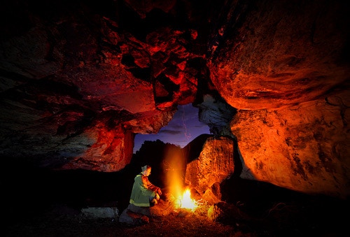 Chimanimani is Zimbabwe's premier hiking destination - a dramatic mountain wilderness straddling the Mozambique border in the southeastern Eastern Highlands. The Chimanimani Mountains, with their quartzite peaks, pristine streams, mountain pools, and challenging trails, offer the country's most rewarding multi-day trekking experiences. Combined with the charming mountain village at its base, Chimanimani delivers authentic adventure far from the tourist crowds.